Friday, June 25, 2010

Cirrus Spissatus Cumulonimbogenitus (CH3)

After a blistering Friday afternoon, I dreaded the hot commute back home, but finally we got some relief in the form of afternoon thunderstorms. There were a few around with cool outflows, but limited areas of rain. Still, the thunderstorms do have another blessing: when they rain out, the Cirrus Spissatus helps keep the sky overcast for the rest of the evening. Specifically generated from Cumulonimbus Capillatus (CL9)(Your typical thunderstorm), this is called Cirrus Spissatus Cumulonimbogenitus (CH3). The downside, is that the cirrus also limits the diurnal heating necessary for further thunderstorm development and stabilizes the atmosphere to some extent.

The high clouds of the anvil separate from the mid and lower clouds and leave a nice veil over the sky. Unlike other cirrus, this is a bit darker and thicker in the middle, while more typical of cirrus around the edges.

These that I took, show the transition from CL9 to CH3.


Thursday, June 24, 2010

Stratocumulus

Posted by Picasa

Evening Sky


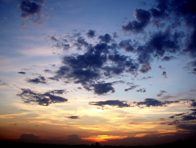
While walking Hank and Gus with Amanda this evening, we were treated to an active sky at sunset. Cumulus Fractus (CL1) in the foreground, with two Cumulonimbus (CL9) thunderstorms on the horizon (these were back towards Huntsville, AL!) and even some altocumulus castellanus (CM8). There were also some examples of altocumulus lenticularis, though I'm not sure I captured those well.

Monday, June 21, 2010

Eastern Colorado Mesocyclone

It is a very active night across the country's heartland with Tornado Warnings out in Montana, Colorado, Kansas, Indiana and Wisconsin. I found this monster on the radar in the plains of Eastern Colorado near the Kansas border. The Goodland, KS radar caught this excellent example of a Doppler tornado.


Lone Solstice Thunderstorm

Walking outside this evening to walk the dogs, I was treated to a beautiful thunderstorm in the distance, peaking over the trees and just tall enough to catch the last rays on the longest day of the year. The storm was one of the few to form over the Metro Atlanta area today, one with temperatures in the mid-90s. I love the contrast between the darkening evening sky and the bright cumulonimbus tower reaching over 25K feet. The pictures don't do it justice.

The Radar Image. The thunderstorm was to my Southwest and was moving quickly to the West.

Sunday, June 13, 2010

Outflow Boundary Thunderstorm: Cherokee/Cobb County

It had been a blistering hot day for late Spring in Georgia. Only a few mountain thuderstorms were present on the FFC WSR-88D Radar around 6PM, but the cold outflow from those storms set off a small intense line of thunderstorms across Cherokee and Cobb Counties by 8PM.

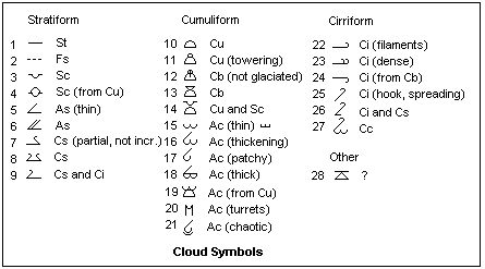
27 Cloud State Symbols


Cloud Classification

While others take time to stop and smell the roses, I stop and stare at the clouds. Sure, the rose offers a variety of colors, blossom stages, and deep green leaves, but it might as well be frozen in time. The sky is alive, ever changing right before our eyes. It's as if the sky is a garden, sprouting new plants constantly, some thriving, while others withering from the start. Ingredients such as convergence, instability, sheer, and warm humid air are the soil, water, and fertlizers in our atmosphere. Still, unlike roses and gardens, I can watch the entire lifespan of a storm in summer afternoon.

After some time staring at white and gray clouds, one begins to wonder how to categorize or classify them. To kill a metaphor for good, one would be mistaken to classify tomatoes and lettuce in a garden as just plants. Sure they're both green and respond well to sunlight and water, but the classification is much too broad. Similarly, clouds have specific classifications for their many species. By learning the classifications, I hope to better appreciate each type.

Currently, there are 10 principle cloud genera recognized world-wide:

HIGH CLOUDS
  • 0 Cirrus (Ci)
  • 1 Cirrocumulus (Cc)
  • 2 Cirrostratus (Cs)

MEDIUM CLOUDS

  • 3 Altocumulus (Ac)
  • 4 Altostratus (As)
  • 5 Nimbostratus (Ns)

LOW CLOUDS

  • 6 Stratocumulus (Sc)
  • 7 Stratus (St)
  • 8 Cumulus (Cu)
  • 9 Cumulonimbus (Cb)

From there, each Cloud Genera has several subspecies, with as many as 11 for Stratus. Future postings will explore each.


June 5th Tornadoes over Northern Plains

Magnolia Iowa Tornado

JUNE 5th TORNADO OUTBREAK OVER IOWA
The National Weather Service Weather Forecast Office (WFO) Quad Cities (IA/IL) has one of the best post-incident weather reports I have seen:
The report includes both reflectivity and velocity radar captures with corresponding images from spotters.